City Centre Movement and Access strategy
Overview
As we transform the city centre into an attractive place to live, work, visit, and do business, it is essential that we free up space previously allocated to private vehicles. Reducing miles travelled by car will improve air quality and encourage greater use of active travel. We understand that the city needs to keep moving and efficient access is essential to all.
The City Centre Movement and Access strategy (CCMA), previously known as City Centre Cells/City Centre Segments, has developed through multiple versions to provide the solutions needed by all users.
Measures to provide safer facilities for active travel have already been effectively introduced over the last few years, including on Newhall Hill, Fleet Street, and Upper Dean Street. CCMA builds on this to create an intuitive go anywhere network that is safe and reliable.
As part of this strategy, we are proposing to introduce a series of measures across the city centre (the area within the A4540 ring road) over the next couple of years. These will be infrastructure and traffic management measures, such as bus gates, bollards, and turning restrictions that will be supported by new directional signage on the approach to and within the A4540 ring road.
When finalised, these interventions will complete the movement and access arrangement shown below, leading to greater use of the ring road for private vehicle trips, and a reduction of vehicle trips on local roads within the city centre.
Private vehicles will not be able to travel directly between the different areas, as shown on the plan below, but public transport and active travel modes will be able to. Private vehicles will be able to enter each area from the ring road only. This means the route to a particular destination might change slightly, but all locations will remain accessible.
Movement and access arrangement: Concept overview
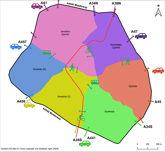
View the image in a new browser window.
Movement and access arrangement: Traffic management cells/areas
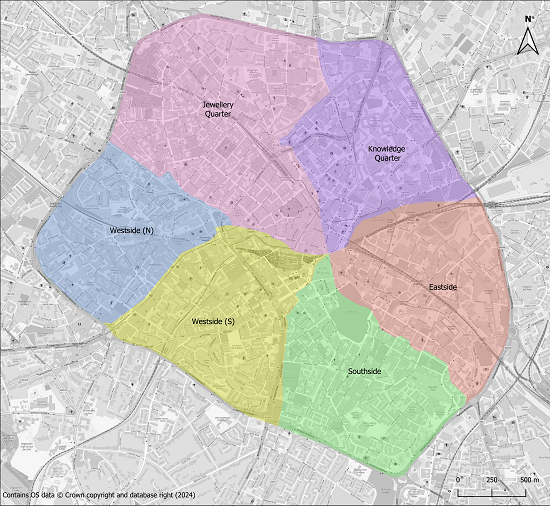
View the image in a new browser window.
Proposed Measures
There are a number of proposed measures across the city centre. A summary of the proposed measures is shown in the table below.
| Location | Cell/Boundary | Intervention |
| Great Charles Street Queensway | City Core | A bus gate (in operation 24 hours) with exemptions for cycles and taxis. |
| Colmore Row | City Core | A bus gate (in operation 11am - 11pm) with exemptions for cycles and taxis. Church Street will be made one-way southbound. |
| Hill Street, Station Street | Southside | Changes to the direction of flow, including a two-way bus only on Hill Street (between Smallbrook Queensway and Hinckley Street). A one-way section on Station Street, and pedestrian crossing improvements. |
| Inge Street, Hurst Street, Bromsgrove Street | Southside | A timed Pedestrian and Cycle Zone (prohibition of motor vehicles, from 7pm - 7am) with exemptions for buses and access to off-street premises. |
| Wrentham Street | Southside | Wrentham Street closed to all traffic except cycles (between Henstead Street and Bristol Street). |
| Lower Trinity Street | Eastside | One-way with a contraflow cycle lane (cyclists able to ride in both directions). A Pedestrian and Cycle Zone (prohibition of motor vehicles from 6pm - 4am) |
| Heath Mill Lane | Eastside | Traffic calming with raised junction tables and priority controlled chicanes |
| Floodgate Street | Eastside | Traffic calming with raised junction tables and priority controlled chicanes |
Find out more about the specific schemes:
Great Charles Street Queensway
The proposed introduction of a two-way bus gate with a U-turn facility will help to reduce the volume of private vehicles passing through this busy area of the city. A measure to restrict private vehicle traffic between Parade and Lyon Queensway will be developed.
View the plan in a new browser window.
Simplified overview drawing:
Colmore Row
The proposed interventions will reduce private vehicle traffic on Colmore Row, freeing up more space for other modes and users, and enhancing the look and feel of this historic location. This is one of four locations looking at specific measures within the wider traffic area arrangement.
Hill Street, Inge Street, Hurst Street, Bromsgrove Street and Wrentham Street
The introduction of a timed pedestrian and cycle zone (prohibition of motor vehicles, from 7pm - 7am) with exemptions for buses and off-street premises to help create safe and enjoyable public spaces for pedestrians and cyclists.
Wrentham Street closed to all traffic except cycles (between Henstead Street and Bristol Street). This firms up the area boundary between Westside South and Southside and will reduce a known vehicle rat-run through this part of the city.
View the plan in a new browser window.
View the plan in a new browser window.
View the plan in a new browser window.
View the plan in a new browser window.
Simplified overview drawings:
View the plan in a new browser window.
Lower Trinity Street, Heath Mill Lane and Floodgate Street
One-way traffic on Lower Trinity Street from northwest to southeast with a contraflow cycle lane (cyclists able to ride in both directions) and associated removal of parking bays. This will be supplemented by a timed Pedestrian and Cycle Zone (prohibition of motor vehicles from 6pm - 4am) from Thursday evening to Monday morning.
Traffic calming measures on Heath Mill Lane and Floodgate Street such as vehicle priority, kerb build outs and raised tabletops will help improve road safety and reduce vehicle speed through the area. Changes to parking restrictions will help facilitate different uses.
View the plan in a new browser window.
Events
-
Drop in session - Council House
From 16 Jul 2024 at 15:00 to 16 Jul 2024 at 18:00An opportunity to view the plans in person, and talk to the project team about the Great Charles Street Queensway, Colmore Row, Hill Street, Navigation Street and Suffolk Street measures in particular. No booking needed.
Full address: Council House, Ground Floor, Room 2, Victoria Square, Birmingham B1 1BB -
Drop in session - Custard Factory
From 17 Jul 2024 at 15:00 to 17 Jul 2024 at 18:00An opportunity to view the plans in person, and talk to the project team about the Lower Trinity Street, Heathmill Lane and Floodgate Street measures in particular. No booking needed.
Full address: Custard Factory Reception, Gibb St, Deritend, Birmingham B9 4AA -
Drop in session - The Southside Building
From 18 Jul 2024 at 15:00 to 18 Jul 2024 at 18:00An opportunity to view the plans in person, and talk to the project team about the Inge Street, Hurst Street, Bromsgrove Street and Wrentham Street measures in particular. No booking needed.
Full address: The Southside Building, 31 Hurst Street, Birmingham, B5 4BD
Areas
- CITY CENTRE
Audiences
- All residents
- Businesses
- Councillors/MPs/MEPs
- Cyclists
- Local Residents
- Motor Vehicle Drivers
- Pedestrians
- People with Disabilities
Interests
- Business
- cycling
- Environment
- Health & Wellbeing
- Transport (Including Walking)
Share
Share on Twitter Share on Facebook