Bournville and Cotteridge Places for People
Feedback updated 19 Sep 2023
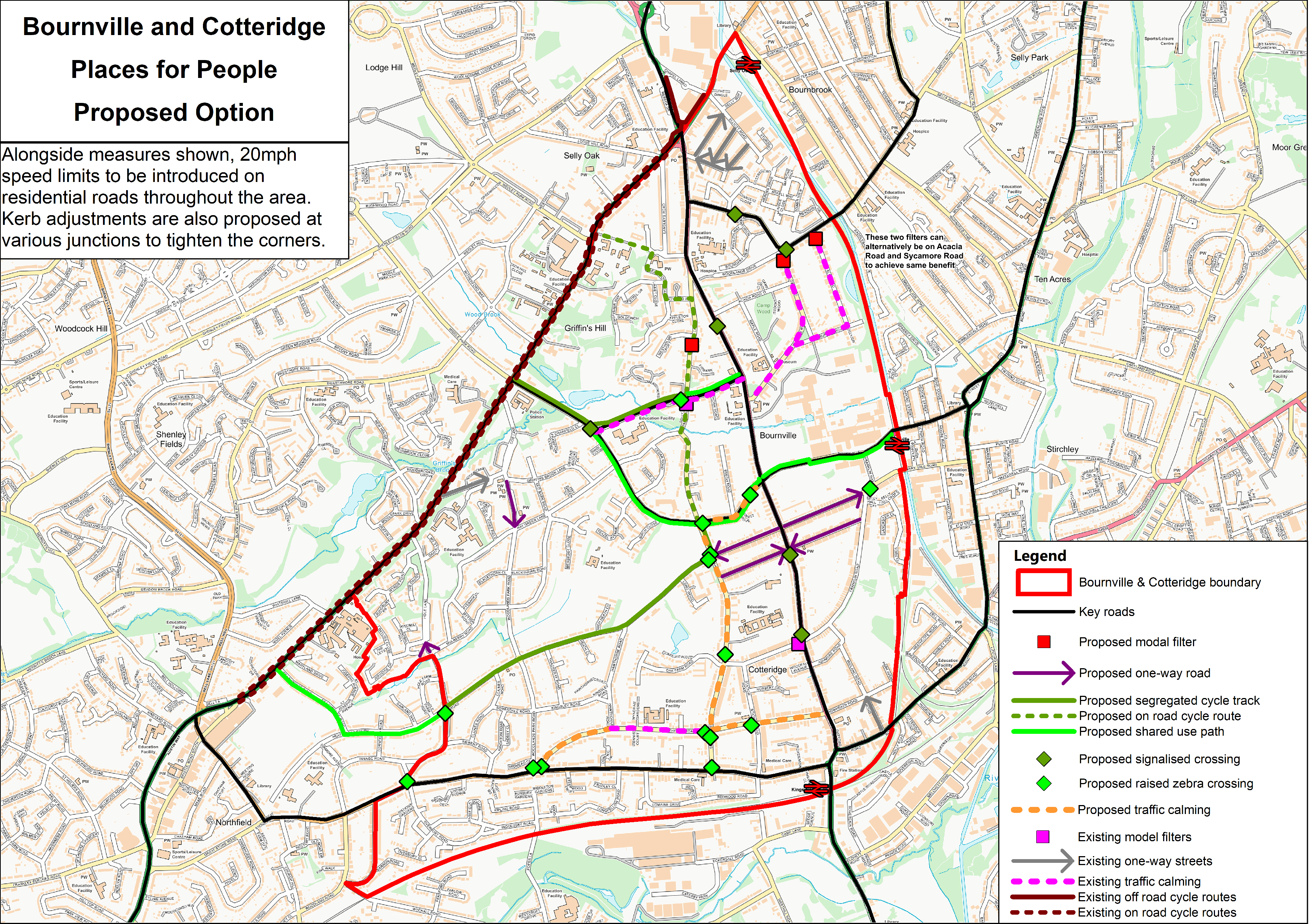
We asked
Between 3 June and 2 July 2023, we ran a consultation on a proposed layout option for this area. The consultation received over 1,200 responses to the online survey, around a further 100 emails, and included two very well attended drop-in sessions.
You said
There was a mixed response to the various proposals consulted on. There was support for the aims and principles of the project, with 46% of respondents expressing positive sentiments towards this compared to 43% expressing negative sentiments.
Concerns were particularly highlighted in relation to:
- the proposed introduction of modal filters on Willow Road and Elm Road
- proposals to make some roads one-way, especially Beaumont Road and Hole Lane
- a proposed segregated cycle track on Heath Road
We did
It is clear that there is a need for further engagement with residents, businesses, and other groups to refine these proposals or develop alternative options. This would be arranged on a localised basis, bringing people together to consider measures for a certain group of streets, while still developing a holistic scheme that delivers benefits across the whole area.
Over the coming months, we will work closely with the Councillors for Bournville & Cotteridge ward, Cllr Liz Clements and Cllr Fred Grindrod, to facilitate further meetings and discussions with residents and other stakeholders to develop ideas for a revised scheme.
Overview
Places for People aims to reduce traffic in residential neighbourhoods so that it is safer for people to walk and cycle, and nicer to be outside for children to play and neighbours to chat.
In many parts of Birmingham, residents find their streets are busy with traffic, particularly when people are taking shortcuts to avoid main roads. When traffic is reduced the neighbourhood becomes quieter, the air is cleaner, and streets feel safer.
The principle of Places for People is that residents can continue to drive onto their street, have visitors, get deliveries, etc, but it is made harder to drive straight through the area.
The story so far
In 2020, we introduced temporary measures in Bournville, placing large planters and bollards on Oak Tree Lane and Franklin Road to prevent motorised vehicles from using these side streets to cut through and avoid main roads.
What now?
We are now planning to extend the scheme across the whole of Bournville & Cotteridge Ward, making some further changes to keep through traffic on the more main roads.
Modal filter – A bollard (or planter) that stops vehicles driving all the way along a street whilst retaining full access for pedestrians and cyclists.
One-way streets – Streets that only allow traffic in one direction, access for critical amenities, such as shops and schools is maintained.
Segregated cycle track – These cycle routes allocate a section of the carriageway/ footway for cycle use only. Some physical separation is often used to stop motor vehicles from entering the space.
On street cycle route – A section of street suitable for cyclists to mix with general traffic, due to low vehicle speed and volume.
Shared use path – A shared path is designed for all types of users including pedestrians, wheelchair users and cyclists. Shared paths may be identified by signs showing a white bicycle and pedestrians on a blue background.
Signalised crossing – Crossings that are controlled by traffic signals for pedestrians, cyclists and vehicles, often used where vehicle speeds are high or where there is a high number of pedestrians and cyclists.
Raised zebra/parallel crossing – Raised zebra crossings combine traffic calming measures with pedestrian crossings, raised parallel crossings include the provision for cyclists to cross without having to dismount. These crossings encourage drivers to travel at their slowest where pedestrians and cyclists are crossing.
Kerb adjustments at junction – The corners of the kerb line at junctions are tightened, which forces vehicles to navigate the junction at a slower speed, widens the footway at the junction, and reduces the crossing distance for pedestrians.
Traffic Calming – Measures such as speed cushions, speed humps and chicanes can be introduced to keep a street open to all traffic but to discourage its use by those who don’t need to use it for local trips.
Events
-
Teams live briefing session
From 14 Jun 2023 at 17:30 to 14 Jun 2023 at 18:30We will give a presentation on the Bournville and Cotteridge Places for People and give you an opportunity to ask the team any questions you have.
Register for the event at: https://bournvillecotteridgepfp.eventbrite.co.uk -
Drop in session - Selly Oak Methodist Church
From 20 Jun 2023 at 16:00 to 20 Jun 2023 at 19:00Come along to chat with members of the team, ask questions and give us your feedback. No need to book, just turn up at any time.
Location: Langleys Rd, Selly Oak, Birmingham B29 6HT -
Drop in session - Dame Elizabeth Hall
From 24 Jun 2023 at 10:00 to 24 Jun 2023 at 13:00Come along to chat with members of the team, ask questions and give us your feedback. No need to book, just turn up at any time.
Location: Dame Elizabeth Hall, Firbank Cl, Bournville, Birmingham B30 1UA
Areas
- Brandwood & King's Heath
- Moseley
- MOSELEY AND KINGS HEATH
Audiences
- Anyone from any background
Interests
- City Centre Parking
- cycling
- Environment
- Health & Wellbeing
- Planning
- Regeneration
- Transport (Including Walking)
- Travel
Share
Share on Twitter Share on Facebook